
2GIS beta
- Maps & Navigation
- 6.44.1.559.3
- 179.3 MB
- by 2gis
- Android 6.0+
- May 01,2025
- Package Name: ru.dublgis.dgismobile4preview
City routes, live traffic, transit routes, parking, offline map and navigation.
We are excited to announce that we have updated 2GIS. The current version of the app struggled to showcase all the detailed information we have about cities and companies. In the new 2GIS, we've revamped the design, introduced a new search feature, enhanced city updates, and integrated favorites with 2gis.ru.
Services, addresses, and companies
2GIS provides comprehensive information about local services. It knows which utility provider services your home, the location of your nearest district hospital, or the closest post office. The app helps you select cafes or service centers based on reviews and photos, and it displays their opening hours and contact numbers.
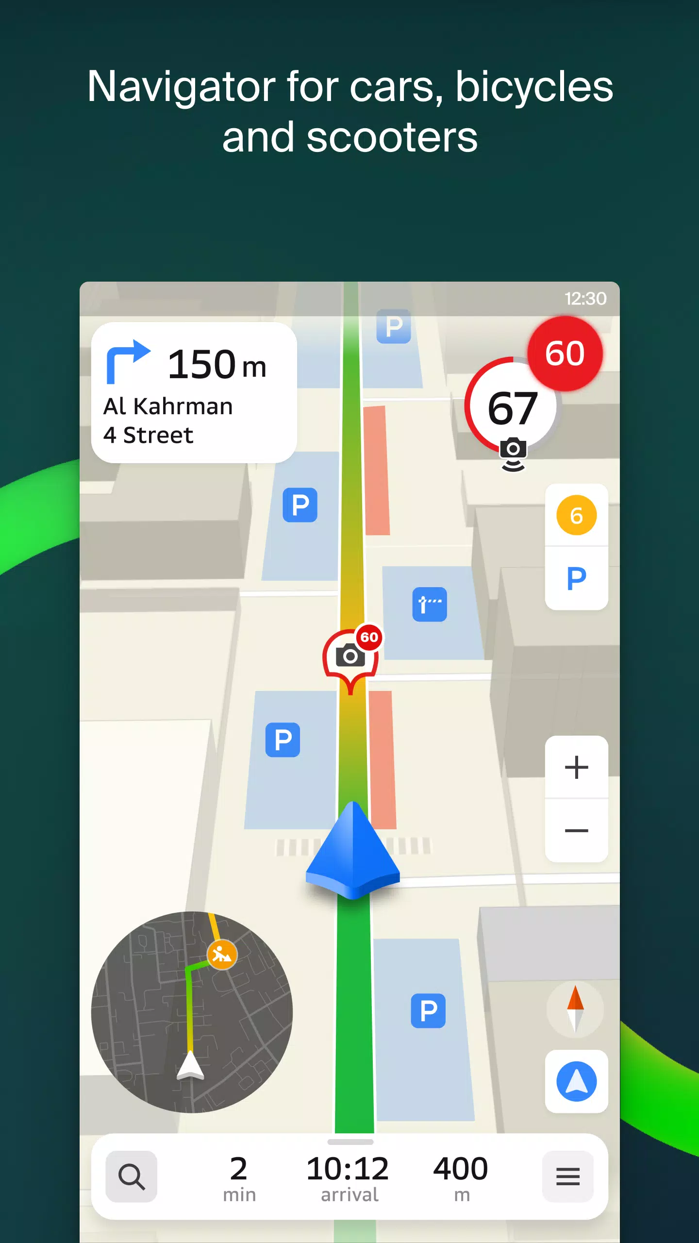
Transport and navigation
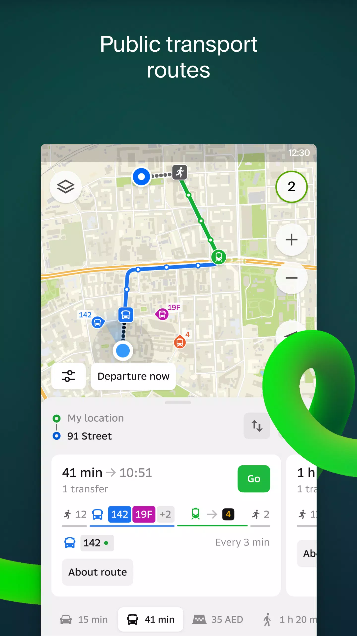
For drivers, 2GIS offers real-time navigation with voice instructions, taking into account traffic conditions and road closures. It dynamically updates your route if you deviate from the planned path. For pedestrians, the app suggests routes using buses, metro, trains, cable cars, and river trams.
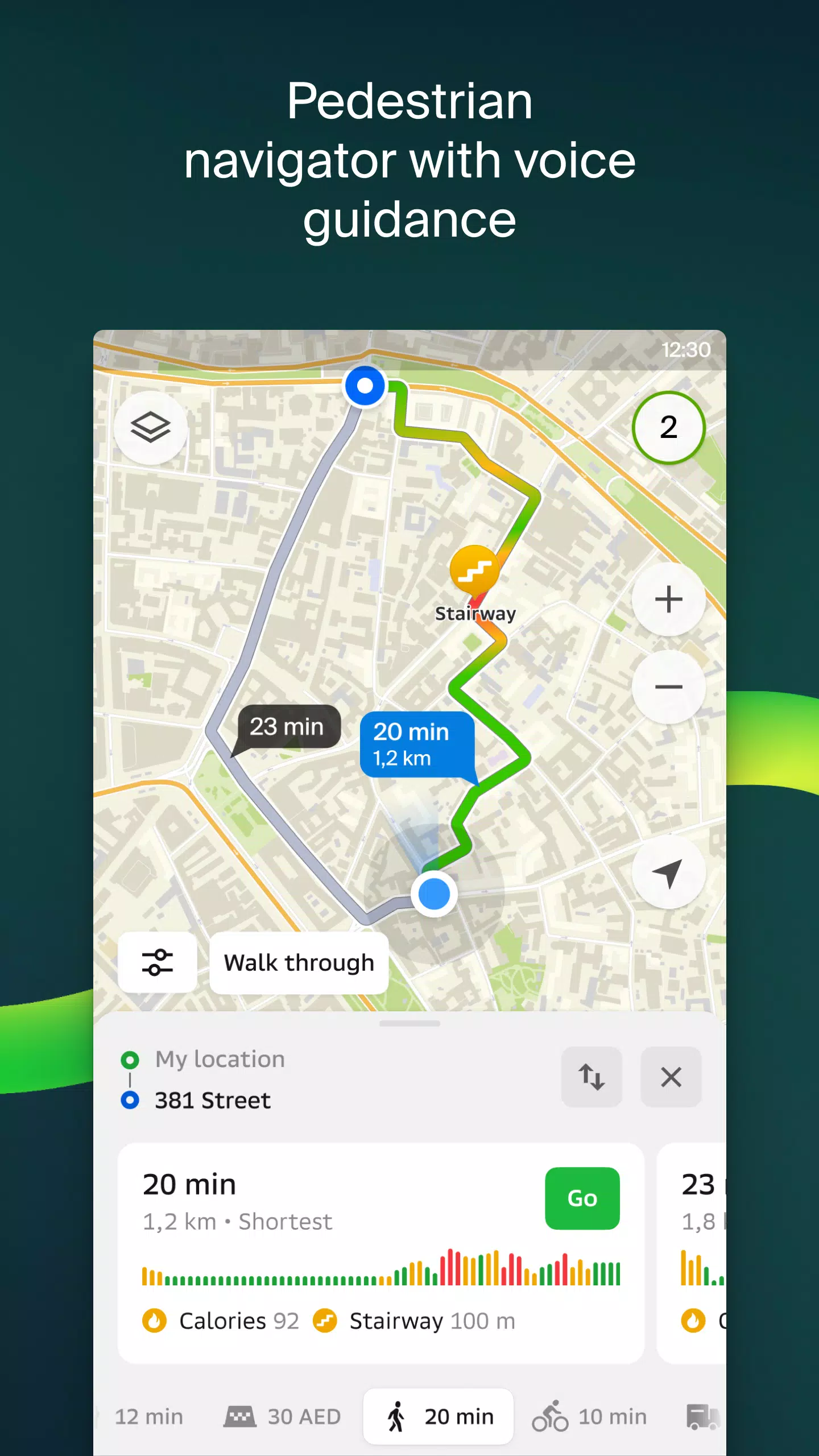
Walking routes
Our pedestrian navigation feature guides you on foot, working seamlessly in the background with voice guidance to ensure you reach your destination effortlessly.
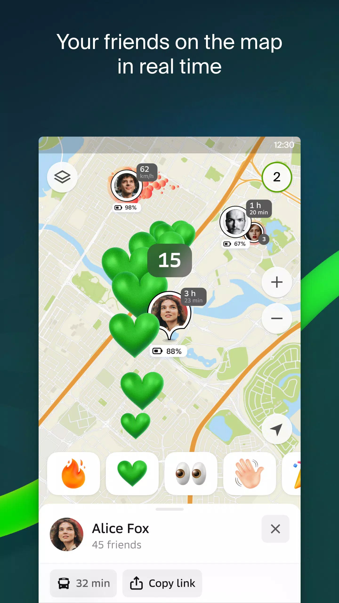
Friends on the map
With 2GIS, you can now track the real-time location of your friends and family on the map. You have full control over who can see your location and who you can see, with customizable visibility settings.
Building entrances
No more wandering around to find the entrance to a business center. 2GIS has detailed information on how to enter over 2.5 million companies. Whether you're using public transport or driving, the app will guide you right to the door.
Plans of shopping centers
Navigate inside shopping centers with ease using 2GIS. The app provides a detailed layout, showing everything from shops and cafes to ATMs and restrooms, helping you plan your visit in advance.
2GIS beta Notifications companion app for smart watches on Wear OS
We've introduced a companion app for smart watches running Wear OS 3.0 or later. This handy tool allows you to navigate routes on foot, by bike, or by public transport directly from your wrist. It displays the map, provides maneuver hints, and sends vibration alerts when you're approaching a turn or your destination bus stop. The companion app automatically starts when you initiate navigation on your phone.
By joining the beta, you'll receive the latest updates as we fix bugs and errors, contributing to the development of a new version of 2GIS that will be used by millions. You don't need to uninstall the original version; the beta version runs concurrently, allowing you to switch between them at any time.
Support: [email protected]
What's New in the Latest Version 6.44.1.559.3
Last updated on Oct 19, 2024
We're thrilled to bring you beautiful, crisp updates in the latest version of 2GIS:
- We now display wide, realistic roads on the main map and when searching for routes.
- Introducing much-anticipated Chats for Friends! Message each other without leaving the map.
- Added notifications when a friend is nearby (can be turned off in settings).
- Just in time for ski season: we've added ski lift statuses on slopes: see whether they're open or not.
- If your public transport route includes walking, we’ll calculate the walking part in steps.


-
 HP Omen 17 RTX 4070 Laptop Drops to $1,199.99 After 20% Off
HP is running a fantastic Memorial Day Sale this week, featuring one of its 17-inch gaming laptops at a great price. For just $1199.99 with free shipping, you can get an HP Omen 17" RTX 4070 gaming laptop by applying the 20% off coupon code "LEVELUP2
May 02,2026 -
 Whitethorn Catalog Launches on Cloud Gaming's Blacknut
Whitethorn Games is bringing its hit titles to mobile platforms.All this is happening through the Blacknut streaming service.Starting July 25th, fans can dive into games like Calico and Aground.Whitethorn Games, the publisher behind popular titles li
May 02,2026 - ◇ 10 Tips and Tricks to Master RAVEN 2 Apr 30,2026
- ◇ Neon Spellstorm: Wizard Roguelite Bullet Heaven Pre-Registration Now Open Apr 29,2026
- ◇ Assassin's Creed: Shadows May Launch on Switch 2 Apr 27,2026
- ◇ Double Fine reveals Keeper: Lighthouse game with bird powers Apr 22,2026
- ◇ Beginner's Guide to Mastering NBA-Licensed Streetball Apr 22,2026
- ◇ How to Play Battlesmiths: Craft World on PC with BlueStacks Apr 17,2026
- ◇ Halloween Event Haunts June's Journey Hotel Apr 15,2026
- ◇ Harry Potter Game Update: Boost Relationships This Valentine's Day Apr 15,2026
- ◇ Squelch for PC, PS5 & Xbox Series Apr 08,2026
- ◇ The Powerful AMD Ryzen 9800X3D and 9950X3D Gaming CPUs Are in Stock and Slightly Discounted Apr 08,2026


![Zenless Zone Zero [ZZZ] Codes (December 2024) – 1.4 Livestream Codes](https://imgs.96xs.com/uploads/54/1735628542677396feeb34f.jpg)

- 1 WWE 2K24 Update 1.11 Released Nov 10,2024
- 2 Capcom Spotlight February 2025 and Monster Hunter Wilds Showcase: Everything Announced Mar 05,2025
- 3 New LEGO Sets for March 2025: Bluey, Harry Potter, and More Mar 06,2025
- 4 PUBG Mobile Redeem Codes for January 2025 Live Now Feb 13,2025
- 5 Gothic 1 Remake Demo: Frame-by-Frame Comparison with Original May 01,2025
- 6 "Assassin's Creed Shadows Unveils Canon Mode" Apr 26,2025
- 7 Pokémon TCG Pocket Unveils Premium Pass and Trade Tokens Apr 21,2025
- 8 Roblox's RNG War TD Codes Unleashed (2025 Update) Feb 12,2025


-
Top Business Management Apps for Android
A total of 10
-
Best Racing Games to Play Now
A total of 10
-
Best Competitive Multiplayer Games on Android
A total of 10