
All-In-One Offline Maps
- Maps & Navigation
- 3.15d
- 7.2 MB
- by Psyberia
- Android 2.1+
- May 01,2025
- Package Name: net.psyberia.offlinemaps
OfflineMaps provides you with access to a diverse array of maps, ensuring that you can navigate with ease wherever you go. With a commitment to user privacy and a seamless experience, OfflineMaps boasts **no advertisements, no data sharing or monetization, no analytics, and no third-party libraries**. Say goodbye to waiting for maps to load—All-In-One OfflineMaps stores maps once displayed, making them readily available even without network access.
- Want more than just roads on your maps? OfflineMaps has you covered with everything you need;
- Frequently visit areas with poor network coverage? Your maps will remain accessible;
- Traveling abroad? Never worry about getting lost again;
- Concerned about data limits? OfflineMaps helps reduce your data usage.
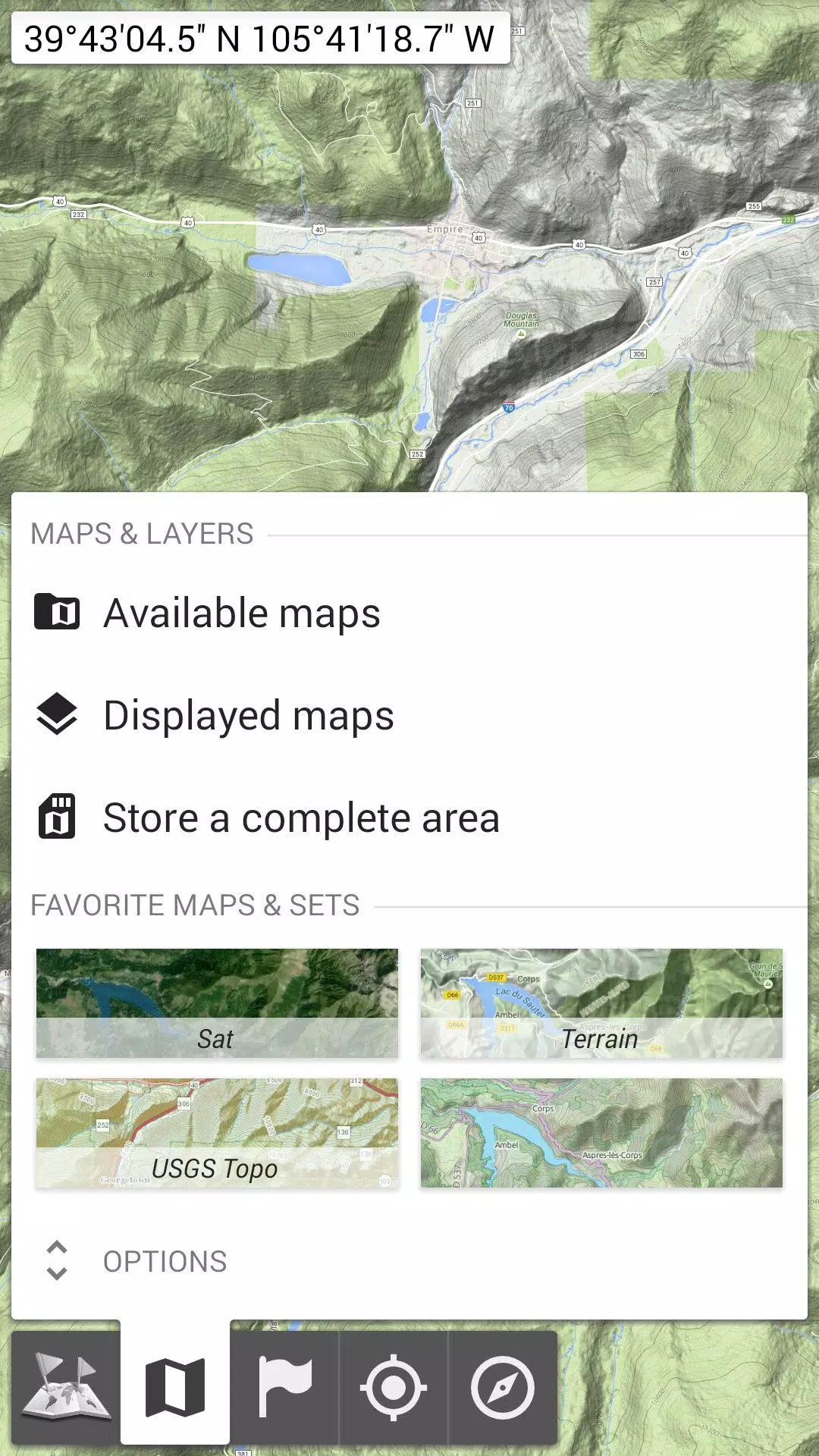
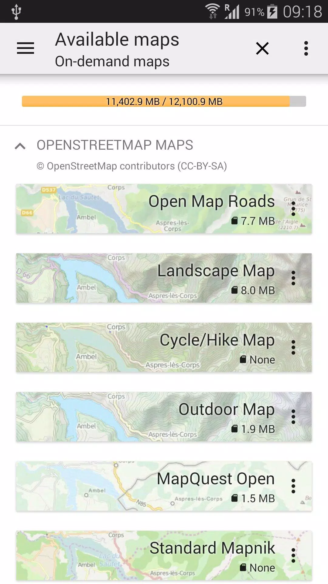
★★ Maps ★★
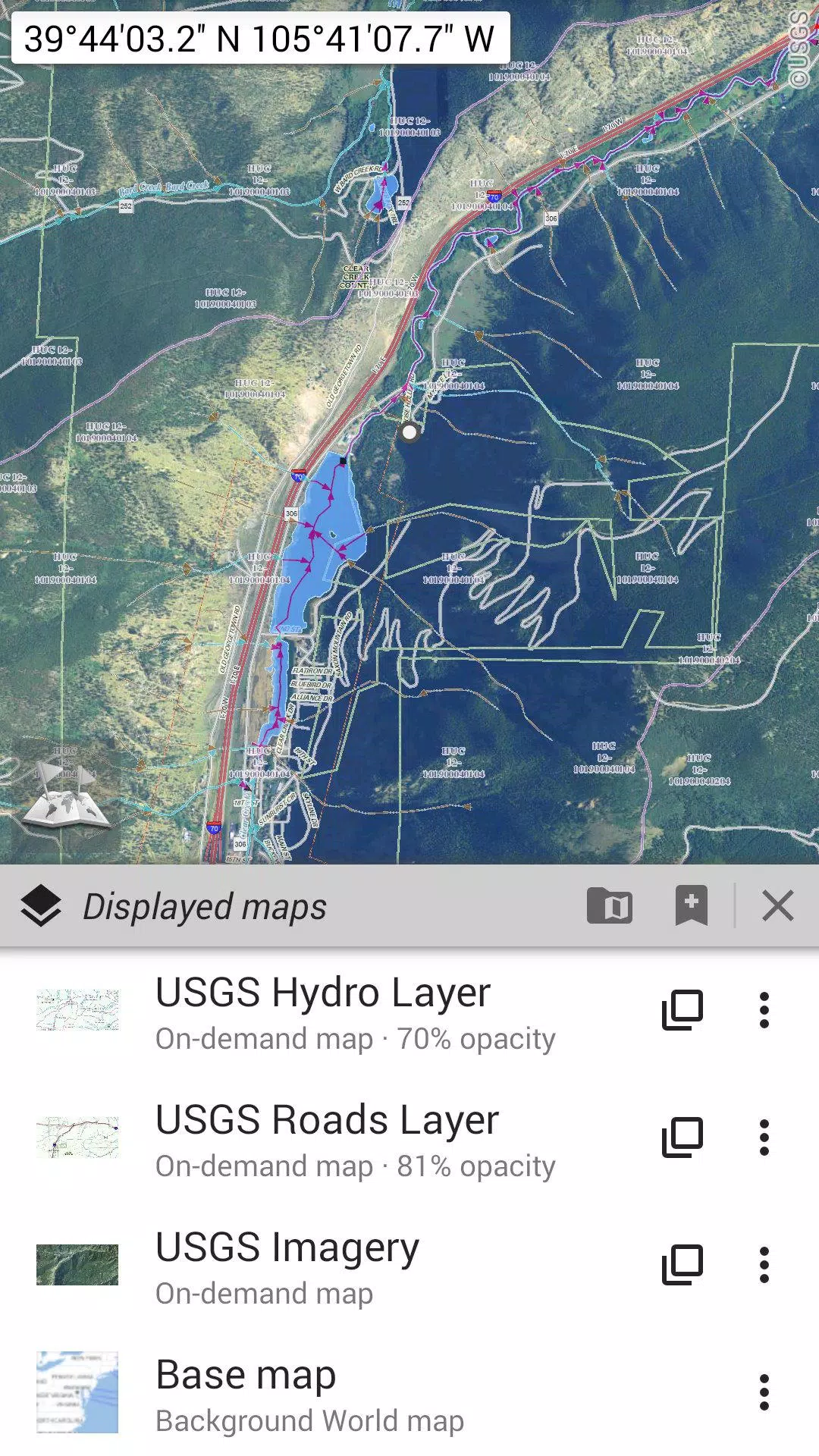
Explore a vast selection of maps, from traditional road maps to detailed topographic and aerial (satellite) maps. Enhance your maps with various layers such as OpenStreetMap (Roads, Topo), USGS National Map (Hi-res topo, Aerial imagery), and Worldwide Military Soviet topo maps, among others.
- All maps can be layered with precise opacity control;
- Select and store large areas with just a few clicks;
- Manage stored space easily and delete when necessary.
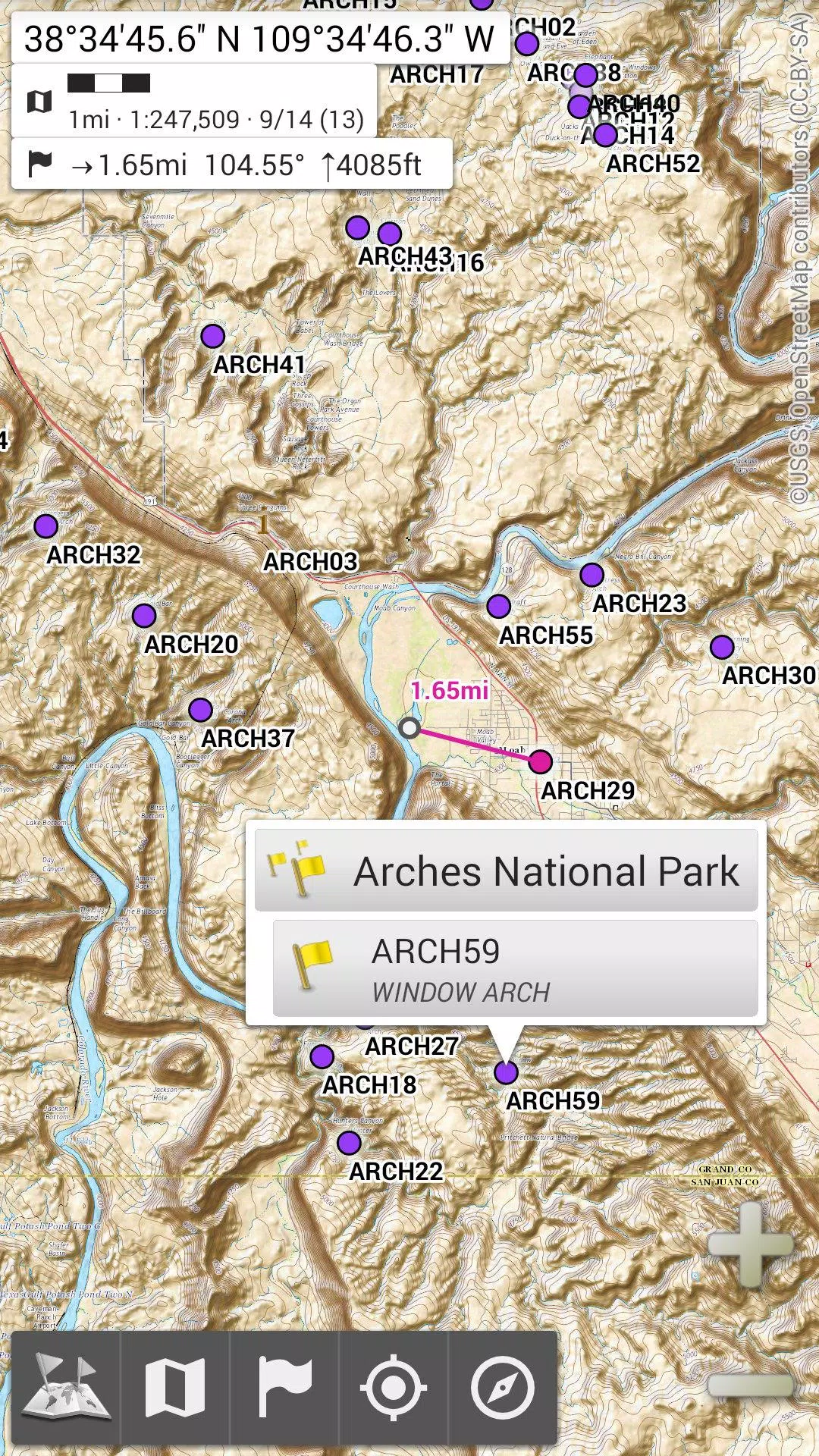
★★ Display, Store, and Retrieve Unlimited Placemarks ★★
Enhance your maps by adding waypoints, icons, routes, areas, and tracks. Manage these items effortlessly with the powerful SD-Card Placemarks Explorer.
★★ On-Map GPS Location & Orientation ★★
Your real-time location and direction are clearly shown on the map, which can be rotated to align with your actual orientation (depending on your device's capabilities). Easily toggle this feature on and off to conserve battery life.
Additional features include:
- Metric, imperial, and hybrid distance units;
- GPS Latitude/Longitude and various grid coordinate formats (UTM, MGRS, USNG, OSGB Grid, Irish Grid, Swiss Grid, Lambert Grids, DFCI Grid, QTH Maidenhead Locator System, and more);
- Import capabilities for hundreds of coordinate formats from spatialreference.org;
- On-map grid display;
- Full-screen map view;
- Multi-touch zoom;
- And much more...
★★ Need More? ★★
For the ultimate outdoor adventure, consider AlpineQuest Off-Road Explorer, the comprehensive outdoor solution built on All-In-One OfflineMaps. It includes a powerful GPS Track Recorder and additional features to enhance your exploration. Learn more at alpinequest.net/google-play.


-
 HP Omen 17 RTX 4070 Laptop Drops to $1,199.99 After 20% Off
HP is running a fantastic Memorial Day Sale this week, featuring one of its 17-inch gaming laptops at a great price. For just $1199.99 with free shipping, you can get an HP Omen 17" RTX 4070 gaming laptop by applying the 20% off coupon code "LEVELUP2
May 02,2026 -
 Whitethorn Catalog Launches on Cloud Gaming's Blacknut
Whitethorn Games is bringing its hit titles to mobile platforms.All this is happening through the Blacknut streaming service.Starting July 25th, fans can dive into games like Calico and Aground.Whitethorn Games, the publisher behind popular titles li
May 02,2026 - ◇ 10 Tips and Tricks to Master RAVEN 2 Apr 30,2026
- ◇ Neon Spellstorm: Wizard Roguelite Bullet Heaven Pre-Registration Now Open Apr 29,2026
- ◇ Assassin's Creed: Shadows May Launch on Switch 2 Apr 27,2026
- ◇ Double Fine reveals Keeper: Lighthouse game with bird powers Apr 22,2026
- ◇ Beginner's Guide to Mastering NBA-Licensed Streetball Apr 22,2026
- ◇ How to Play Battlesmiths: Craft World on PC with BlueStacks Apr 17,2026
- ◇ Halloween Event Haunts June's Journey Hotel Apr 15,2026
- ◇ Harry Potter Game Update: Boost Relationships This Valentine's Day Apr 15,2026
- ◇ Squelch for PC, PS5 & Xbox Series Apr 08,2026
- ◇ The Powerful AMD Ryzen 9800X3D and 9950X3D Gaming CPUs Are in Stock and Slightly Discounted Apr 08,2026


![Zenless Zone Zero [ZZZ] Codes (December 2024) – 1.4 Livestream Codes](https://imgs.96xs.com/uploads/54/1735628542677396feeb34f.jpg)

- 1 WWE 2K24 Update 1.11 Released Nov 10,2024
- 2 Capcom Spotlight February 2025 and Monster Hunter Wilds Showcase: Everything Announced Mar 05,2025
- 3 New LEGO Sets for March 2025: Bluey, Harry Potter, and More Mar 06,2025
- 4 PUBG Mobile Redeem Codes for January 2025 Live Now Feb 13,2025
- 5 Gothic 1 Remake Demo: Frame-by-Frame Comparison with Original May 01,2025
- 6 "Assassin's Creed Shadows Unveils Canon Mode" Apr 26,2025
- 7 Pokémon TCG Pocket Unveils Premium Pass and Trade Tokens Apr 21,2025
- 8 Roblox's RNG War TD Codes Unleashed (2025 Update) Feb 12,2025


-
Top Business Management Apps for Android
A total of 10
-
Best Racing Games to Play Now
A total of 10
-
Best Competitive Multiplayer Games on Android
A total of 10